
I spent my Saturday night like any other Saturday night, really. I got ready around 5:00 p.m., left my dorm around 6 p.m. and started recording the locations of puddles around campus.
No, not really. I’m definitely an odd person, but I don’t think I am so odd that I would do this every Saturday night (maybe once in a while though). The idea of recording information about puddles came to me when I was biking through one a couple weeks ago — usually, when people bike through puddles, they realize the importance of having a back fender. Your butt will inevitably get wet if you don’t have a protective back fender. I was pondering such important matters when it occurred to me to make a map of puddles so others don’t have to undergo the same strife. So, here it is: a map of puddles at Stanford, to be used to make a protective path home, to take a glimpse at the topography of campus or simply for your viewing pleasure.
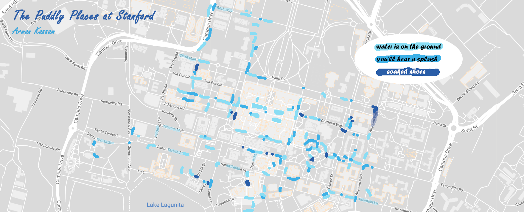
Let me clarify some of the information on this map. First off, there are several limitations to mapping puddles. Namely, it is really hard to record every puddle, let alone a majority of the puddles in the area around main quad. The markings that you see on the map are “puddle zones” that might include anywhere from one to five small bodies of water that have a home at the side (or on) a road or sidewalk. I spent three hours collecting puddle data, walking from Rinconada to Main Quad, then up to the Cantor Arts Center, down to the Engineering Quad, around to the Branner Earth Sciences Building, all the way to FroSoCo (yes, I really did walk to FroSoCo) and then I took a break at TAP. After a hardy meal, I resumed my journey in the direction of Green Quad, moving past Nearillaga and finally returning to my cozy bed in Rinc. Most importantly, I did all of this while it was raining, which might contextualize this map in an important way because the number of puddles during rainfall and the number of puddles the day after rainfall are drastically different.
Needless to say, my shoes were absolutely soaked by the end of this quest.
Also, it might be worth sharing some of the more unexpected and interesting parts of my journey. Easily the most puddly place I came to was the table-area on the side of Tresidder that faces away from White Plaza. There is no other way to put it: it is an ocean out there. Another high-puddle zone is at the intersection of Arguello Way and Serra St, and the puddles in this region are particularly dreadful because they are abnormally large both in terms of surface area and depth.
Please let me know if you know of big puddle zones that are not on the map! I would love to make an updated, cleaner version. Also, please shoot me suggestions for what you want my next map to be about! I will literally make a map about anything (well, not anything — but most things, definitely).
Until next time!
This article is the first in the Mapping Stanford series. Maps from the series can be found at cartacluster.wordpress.com.
Contact Arman Kassam at armank ‘at’ stanford.edu.